The Ground Records: What the Ledger Leaves Out
Economic history is usually written in ledgers, tariffs, and commodity flows. But markets also leave traces on the ground: in the placement of factories, the location of ports, the wall that marks where one merchant’s territory ends and another’s begins. The Architecture of the Bight of Biafra: Spatial Entanglements reads those traces in the built environments of the Èfik people of Old Calabar, in present-day southeastern Nigeria, where five centuries of Atlantic commerce shaped a landscape most economic historians have read through documents alone (Figure 1).
Figure 1. Map of the Biafran region and ethnic groups, showing Old Calabar’s position at the Cross River estuary and its relation to hinterland trading networks.
 Source: Map by Joseph Godlewski and Allison Howard, 2026.
In his recent book, Capitalism in the Colonies, A. G. Hopkins examines the careers of African merchants to show how indigenous entrepreneurs helped build the institutions of capitalism in Lagos. The landscape of Old Calabar makes a similar argument, but from deeper in time and through different evidence. Where Hopkins reads letters, ledgers, and commercial records to recover African agency, this book reads the landscape itself, treating built form as a primary document of economic history, visible in the organization of compounds, the spatial logic of Ékpè lodges, and the placement of imported houses along the waterfront.
Five Landscapes, Five Centuries
The Architecture of the Bight of Biafra provides five spatial paradigms: compound, masquerade, offshore, enclave, and zone. The compound chapter begins in Old Calabar in the sixteenth century, when the walled Èfik compound organized a decentralized trading landscape under the ékpùk lineage system. By the early eighteenth century, as Scottish supercargo Alexander Horsburgh’s ledger makes plain, assemblages of these compounds constituted a landscape of multiple sovereignties operating semi-autonomously in an Atlantic port economy. In 1720 Horsburgh recorded transactions with twenty-six named Èfik merchants; twenty-two years earlier a French trader had noted six. Those twenty new names represent new compounds along the waterfront, new lodges, new spaces of negotiation.
The masquerade chapter examines the Ékpè secret society as the planning and economic institution that managed the growth of the slave trade in the eighteenth century. One of its most visible members was Antera Duke, an Èfik slaver and entrepreneur whose diary, written in pidgin trade English between 1785 and 1788, records the commercial and spatial life of Old Calabar at the height of the trade. At the time, Old Calabar exported some 17,500 slaves per year. Duke’s diary documents, in striking detail, not just transactions but the spaces through which they moved: Ékpè lodges, canoe landings, and imported wooden houses whose windows he hired a ship’s carpenter to install.
An engraving titled “Slave Market” (Marché d’esclaves), made in 1725 and later published in a French trade manual circulated among European merchants, was among the first visual representations of the slave trade in Europe (Figure 2). In the upper panel, a tricorn-capped English slave trader “tastes the sweat of a slave” to detect disease before purchase. Below, a European cargo ship waits anchored in the Calabar River while a canoe transports captives from the shore. What the image does not advertise, but what a closer reading reveals, is that the canoe is paddled by Black men operating as trading agents. The landscape of racial capitalism was not a landscape of simple European domination. It was a landscape of entangled dependencies, in which African entrepreneurial agency and the violence of racial hierarchy occupied the same waterfront, and often the same canoe.
Figure 2. “Slave Market (Marché d’esclaves),” engraving by Serge Daget, 1725.
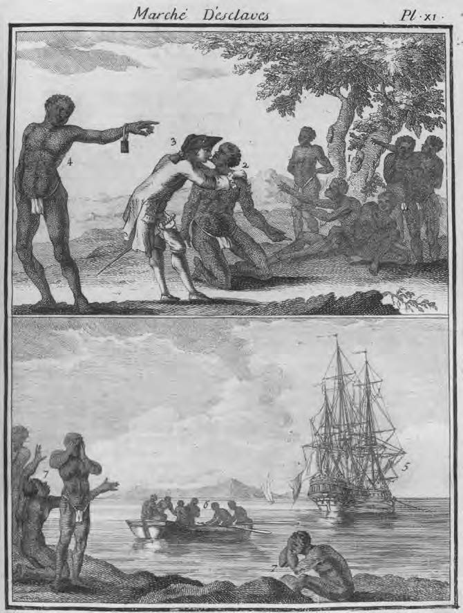
Source: M. Chambon, Le commerce de l’Amérique par Marseille… (Avignon, France: n.p., 1764), Plate XI, 400. Image courtesy of the Bibliothèque nationale de France.
Ékpè regularized exchange, enforced debt payment, and settled conflicts with European traders anchored in the river. Historian A.J.H. Latham (1973, p. 29–30) described it as an “elementary capitalist institution of entirely African origin.” Its lodges were the clearing houses of an Atlantic port economy and the infrastructure of an indigenous planning system.
A Supply Chain Visible from the River
The transition from enslaved people to palm oil as Old Calabar’s primary export commodity produced a new landscape: the offshore. Exports from Old Calabar totaled roughly 1,200 tons between 1812 and 1817. By 1847 alone, that figure had quadrupled to 5,217 tons, driven by British factories using palm oil as industrial lubricant and soap ingredient. Great Duke Ephraim consolidated power over Old Calabar’s external trade after 1814, channeling Atlantic wealth into satellite plantations, prefabricated houses imported from Liverpool, and tightly governed port access that kept European traders offshore for decades. Chief Egbo Bassey’s prefabricated house, shipped from Germany in 1883 and still standing in Duke Town today, continues the same pattern. The landscape registered that shift in every house, factory, and plantation visible from the river (Figure 3).
Figure 3. “Old Calabar Factories, Near Duke Town,” 1885.
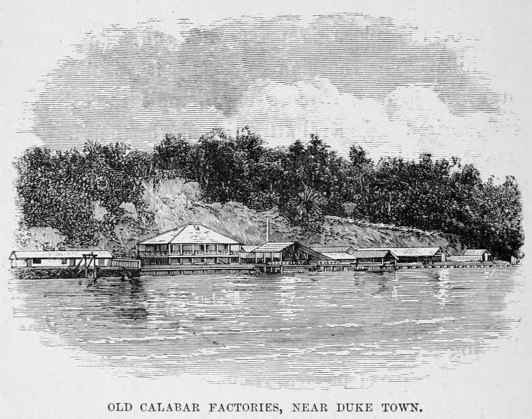
Source: Henry Morton Stanley, The Congo and the Founding of Its Free State: A Story of Work and Exploration, Volume 2. (London, UK: S. Low, Marston, Searle & Rivington, 1885), 232.
The final chapter extends this analysis into the present. Conventional narratives place the origin of special economic zones in China in the 1970s and trace their spread to the global proliferation of neoliberal policy. Tinapa Free Zone and Resort, a large state-sponsored complex that opened in 2007 outside Calabar, is typically read within that frame. Tracing economic enclaving in Calabar, from Ékpè lodges to colonial factory districts to the Royal Niger Company’s trading enclaves, shows that semi-autonomous zones with their own rules of access and debt enforcement have shaped this landscape since the sixteenth century. When the ground is read as a primary document, the history of economic enclaving does not begin in the 1970s — it begins here.
References
Dike, K.O. Trade and Politics in the Niger Delta 1830–1885. Oxford: Clarendon Press, 1956.
Godlewski, J. The Architecture of the Bight of Biafra: Spatial Entanglements, Routledge, 2024.
Hopkins, A.G. Capitalism in the Colonies: African Merchants in Lagos, 1851–1931. Princeton: Princeton University Press, 2024.
Latham, A.J.H. Old Calabar, 1600–1891: The Impact of the International Economy upon a Traditional Society. Oxford: Clarendon Press, 1973.
Lynn, Martin. Commerce and Economic Change in West Africa: The Palm Oil Trade in the Nineteenth Century. Cambridge: Cambridge University Press, 2002.
Northrup, David. Trade Without Rulers: Pre-Colonial Economic Development in South-Eastern Nigeria. Oxford: Clarendon Press, 1978.
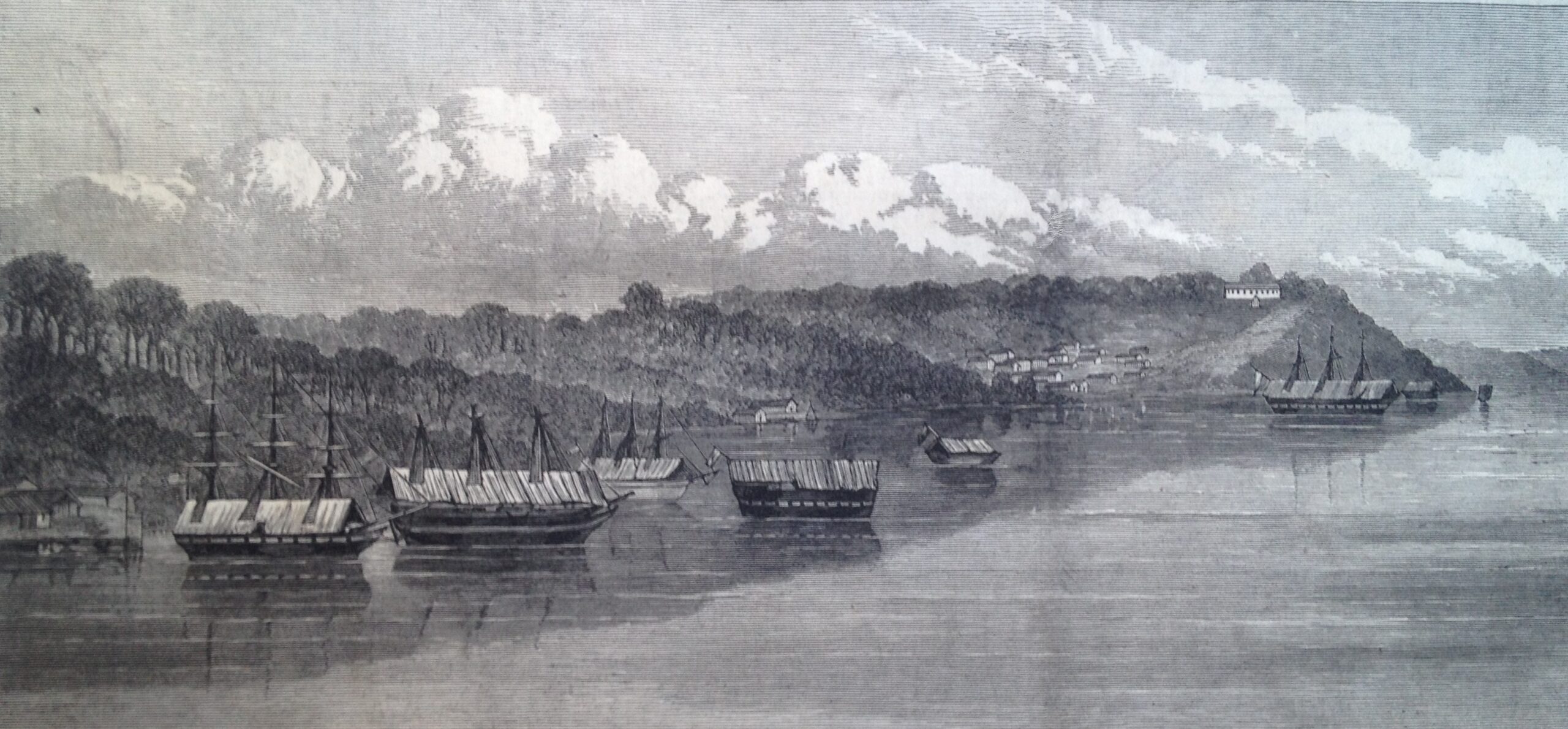
Feature Image. “Old Calabar, West Coast of Africa,” 1873. Source: “Old Calabar,” Illustrated News of London, 18 October 1873: 376.